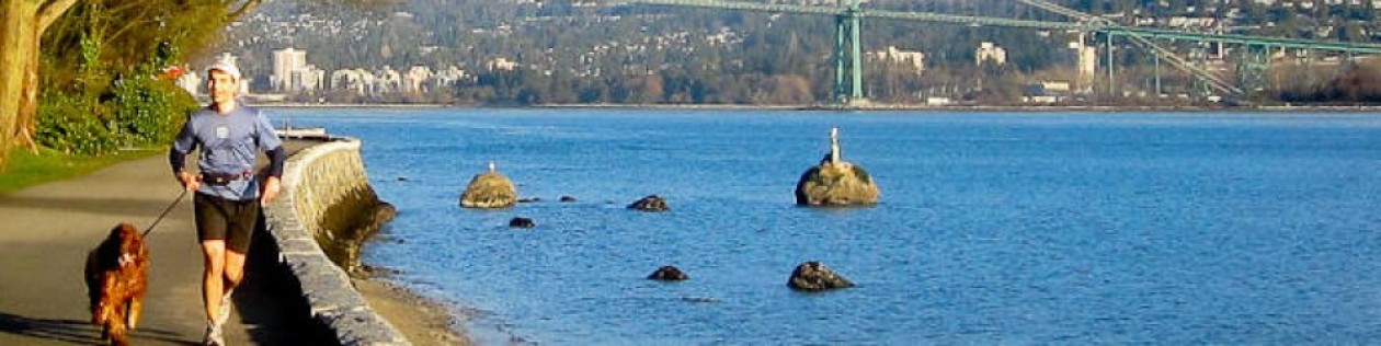
At Long Branch, I usually stayed at the Ocean Place hotel. That is a very nice hotel, right on the Atlantic Ocean (as the name suggests). I enjoyed going to sleep with the soothing sounds of the ocean waves.
For running, there is pretty much only one option; the boardwalk. That is a nice route although not very long. It goes along the ocean (obviously), there is no traffic and the air is fresh (well, New Jersey fresh). I would usually go south from the hotel, then back. To the south, the boardwalk goes to Brighton Avenue and to the north, it only goes to Seaview Avenue.
On the day I recorded this, I went for the total of 3 miles at 7 min 20 second per mile. That is really a minimum distance for it to qualify as a run. Anything shorter than that is a warm-up.
At Lansdale, I always stayed at Homewood Suites on Church Road. From the hotel, I would run down the Church Road to Sumneytown Pike, continue to the entrance of Merck campus, and then back up on the Church Road. Sometimes I would go straight to the hotel, and sometimes I would continue to Main Street and then back to the hotel.
This was not the most pleasant route, most of it was on busy streets, but any run is better than no run I guess. On the day when I recorded this, my total running distance was about 4.5 miles.
Our house in Salt Lake City was above the Foothill Drive, few blocks from the edge of the town. Most days, Maggie and I would run up to the Wasatch Drive and from there either go south, to the I-80 and back, or north, to the Bonneville golf course and back. Both of those routes were about 3 miles. For longer runs, we went the southern route first, and then instead of turning left to go home from Wasatch Drive, continue north to the golf course. Maggie loved the golf course. Wide open green and the lot of wild life (foxes, bunnies, seagulls and deer). Since we always ran very early, we never saw any people the golf course (we did see a lot of animals though). Every time when we went the southern route first, Maggie would start pulling to the right as we are getting closer to our street on the way back (we would turn left there if going back home). She really wanted to go to that golf course each time.
One morning, the gate for our back yard was open and Maggie ran to the golf course and back into the house all by herself. We would have never known that happened, had it not been for our neighbors who followed her back to the house and told us what happened.
Even though most of the running was on the streets, these were very nice routes. The neighborhoods these routes go through are very nice, views are absolutely incredible and there is very little traffic, especially early in the morning. There were a number of trails near our house, but they were all quite steep and rocky. Running up would be hard, but running down would be very dangerous.
Maggie and I did not have to go far from our house in Salt Lake City to be in the wilderness. There were a lot of great trails just few blocks from our house. One of our favorite hiking routes was “antenna hike” shown on the image below. This route went from our house to an antenna which was on one of the smaller peaks (I never figured out what that thing was) and then back to the house. For me, the antenna represented a goal to achieve, something to aim for, to make sure I do not quit half way up. Maggie probably did not care about the antenna, but she was always happy to go anyway.
Getting there was quite a challenge. Round trip distance was only 4.1 miles, but it was very steep. We would usually go up to the letter “H”, and then continue up the ridge all the way to the antenna. From there, we would come down the other side of the mountain, circle around and take Wasatch Drive back to our street. This was a nice hike albeit a very strenuous one. The hills outside the city are very rocky with very few small trees (Utah is a desert after all). If you try it, take your time, and be very careful, especially going down. It is very easy to roll your ankle on one of the loose rocks.
My climb to the Harding Ice field was between a hike and a run. I was trying to decide whether to include it or not, but once I took another look at the pictures from the climb, it seemed quite obvious that I’ve been mostly running so here it is…
Earlier that day, I took a boat tour of the Kenai Fjords National Park. After that was done, driving towards the Anchorage, I noticed a sign for the Exit Glacier and I went to check it out. Harding Ice Field trail head was near the parking lot. I have not heard of this trail before, but the sign said it was only 4 miles to the top and I figured it would have great views. I had little over 3 hours of daylight left, which I thought was plenty. Back then, I’ve been running routinely 6-8 miles, and I was in decent shape.
I signed the log book and took off (by myself). After a first ¼ mile or so, it became obvious that this will be quite a challenge. Calling this trail steep and strenuous is a major understatement. The elevation gain is about 4000 ft over the course of 4 miles! On some parts I almost had to scramble on all fours. Still, I kept running and running. I took few stops along the way to take selfies and pictures of the ice. I finished my run/hike and logged out 2 hours and 58 min after I started. That included some 30 min at the top, chilling out near the ice field, and few minutes here and there to take pictures. I have to say, this trail and the views are out-of-this-world. It was really worth it but I was very tired. I can definitely recommend this hike, but please, take it easy and give yourself a lot of time. I almost broke my leg on the way down.
Looking back now, I realize how insane this whole thing was. Since then, I’ve tried to reach the Harding Ice field two more times with my friend and both times we failed to make it to the end of the trail. Once we had to turn back due to the very bad weather and near 0 ft visibility, and the second time we had big problems with Grizzly bears on the trail, and then, my friend fell through the ice and injured his leg so we had to turn back.
Exit glacier and the Harding Ice Field Trail overview
Running up the Harding Ice Field trail
Taking a short break at the Harding Ice Field Shelter
When I started running, way back in 2000, my favorite trail was the Pennypack trail. Few of us would drive there from Fox Chase Cancer Center after work, and go for 3-5 mile run, depending on how much time we had. We run there many times, too many to remember each one separately. My best guess is that we started probably in July 2000.
Pannypack trail is probably the best place to go running in Northeast Philadelphia area. Driving north on the Pine Rd brings you straight to the park. Just before the Pine Road crosses Pennypack creek, there is a park entrance on the right and the trail head is at the far end of the parking lot. I am not sure know how long the trail is, but it seems on the map that it goes all the way to the Delaware river. The longest I ever run there was 6 miles round trip (so 3 miles down the trail, then back the same way). I do not have any pictures, or GPS tracks, but I am including this Google Earth view. The parking lot is in the middle and the trailhead is just to the right.
Pennypack trail head – Parking lot at the Pine Rd.